


Looking from above these four gods should protect the city:
Behind --The Black Turtle (genbu 玄武) (north)
In front--The Vermillion Bird (suzaku 朱雀) (south)
On the left--The Azure Dragon (seiryū青龍) (east)
On the right-- The White Tiger (byakko白虎) (west)
On December 15, 2009 Gordon and I attended a lecture given by Ellen van Goethem. She is the author of Nagaoka: Japan’s Forgotten Capital (Brill, 2008). Her topic was: Questioning the Landscape: In Search of the Four Gods Protecting Japan’s Chinese-style Capitals.
Here is a brief summary of the main points of the lecture. Geophysical divination was used to find a site where the four guardian gods are in balance (四神相応 shijin sōō). The term shijin sōō has been used by sholars to explain how the ancient capitals were chosen. But this term can be found first in the Sakuteiki(作庭記-Notes on the Making of Gardens) attributed to Tachibana no Toshitsuna (1028–94). According to this 11th century text an auspicious site should have a mountain to the north, a river to the east, a road to the west, and a plain to the south. However this text dates 200 years after the founding of Heian Kyo.
In contrast , the traditional system from China held that the four guardian gods were blessed and the site was auspicious when it had three mountains protecting the city from the north, east and west and the southern section had a plain with water, providing an opening for sunshine and light. The later, modified system had four different topographical features which befit the gods: a moutain, a road, a river,and plain with water.
It has long been held that this new system of providing topographical features for the gods was particular to Japan. Professor van Goethem explained that there were continental texts which offered this modified version of picking auspicious sites. Specifically she sites the Dili xinshu 地理新書 (New Book on Feng Shui) written between 1036 and 1070. This text appeared a few decades before the Tachibana text. Secondly, it was believed that this system helped in picking the Chinese-style capitals. Professor van Goethem argued that this modified system was not used as a system for choosing Chinese-style capitals in Japan but rather the ideas in the Sakuteiki were offered as guidance in how to make a house or a villa within the capital an auspicious site.
Some key points to the lecture were vocabulary. How to define this process of finding an auspicious site. Feng shui is not suitable as it's a very modern concept. Topomancy was suggested as an appropriate term. Topomancy is a mix of Confucianism, Taoist ideas including the 5 elements, position of the moon, the 60 year cycle, and Omyodo- the balance of yin and yang.
In Japan, the earliest recorded use of site-divination was in 513. It was done by a certain Wajchi who was offered by the Paekche court. In 575 site divination was done using bamboo sticks(sochi). In 676 a divination bureau was formed. In contrast to the Chinese court it conflated both the divination and astrology agencies.
The connection between the gods and the four directions can be found in the Zhang shu 葬書 (Book of Burial) attributed to Guo Pu 郭璞 (276–324 CE) This text was translated by Stephen L. Field and can be found here: http://www.fengshuigate.com/zangshu.html
It explained that one should be buried with a cerulean dragon to the left, a white tiger to the right, a vermillion bird in front and a dark turtle behind. An example is the Kitora Tumulus. This site has good photos and an excellent explanation of the astrology from Kitora Tumulus: http://www2.gol.com/users/stever/kitora.htm
To summarize, the Sakutei presented a modified version balancing the four protecting guards with specific features in the landscape. The traditional version sought only natural aspects of the terrain. The four guardian gods were in balance when there were three mountains in a horseshoe shape with a plain with water to the south and an additional mountain to the distant south.
With this in mind we can look at the ancient capitals.
1. Fujiwara kyo
It seems to have been selected using the traditional model, i.e. 4 mountains.
This poem from the Manyoshu shows this clearly.
The green hill of Kagu of Yamato
Stands at the eastern gate,
A luxuriant springtime hill;
Unebi, with its fragrant slopes,
Rises at the western gate,
Ever fresh and flourishing;
Miminashi, the green sedgy mound,
Rears at the northern gate
Its form divine;
And the mountains of Yoshinu, of lovely name,
Soar into the sky,
Far from the southern gate. (Higuchi 1983)
2. Nara. Also seems to have used the 3-mountain and open south plan.
3. Nagaoka.
North. Mt Sawa
West Mt. Nishiyama
East Mt. Fukakusa
South Mt. Katano and Lake Ogura
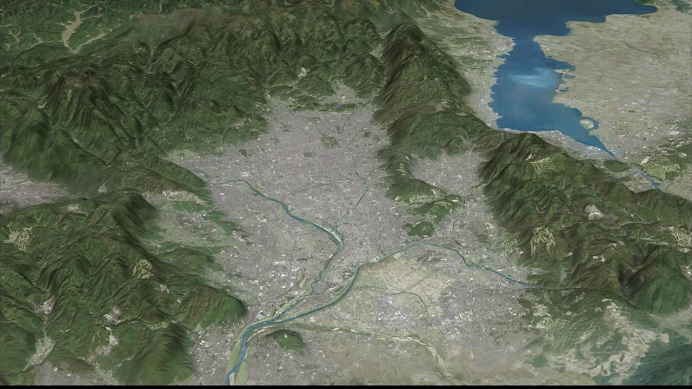
4. Heian-kyo
North Mt. Tanba
West Mt. Hira
East Mt. Arashiyama
South Ogura Pond/Lake
What is interesting is that the modified version is more commonly known. It has:
North Mt Funaoka
West San-indo or San-yodo road
East Kamo River
South Ogura Pond/Lake
West Mt. Nishiyama
East Mt. Fukakusa
South Mt. Katano and Lake Ogura
4. Heian-kyo
North Mt. Tanba
West Mt. Hira
East Mt. Arashiyama
South Ogura Pond/Lake
What is interesting is that the modified version is more commonly known. It has:
North Mt Funaoka
West San-indo or San-yodo road
East Kamo River
South Ogura Pond/Lake
Thank you for the lengthy posting. Just to get the Heian-kyo situation straight, it seems the speaker's contention is that:
ReplyDelete1) the site was chosen by pre-feng shui divination
2) this required a horseshoe shape with an open southern side containing water...
Was the road to the west and the river to the east a requirement for Heian-kyo, and if so did that come from China?
This leaves me with the question as to what role the four guardian animals play, and how exactly are they manifest?
I'm also surprised that there is no mention of the 'kimon' north-east devil's corner. I was particularly looking forward to reading whether this had any Chinese correspondence, and if not how and when it developed....
#1, yes, she said topomancy is the most accurate term. Of course "fu" and "sui" were taken into consideration. It is just that feng shui is a modern term which is probably quite distant from their system.
ReplyDelete#2 yes, the gods were in balance when the horseshoe shape could be found in the terrain.
The road to the west was not a requirement and not a necessity to please the the white tiger. Yes it did come from China in that it was a system more for indivual houses or things like military camps. If there were no mountains, they could substitute the mountain with certain trees or man-made structures like roads which would be pleasing to the gods.
The animals are ancient(2nd century) guardian gods for the Emperor, I think especially connected with burial rites. This site has excellent explanation--
http://www.onmarkproductions.com/html/ssu-ling.shtml
They came into Japan in the 7th century and appeared in some kofun. Onmyodo was predominant at that time. Things had to be in balance. The cardinal directions with the sky, with the elements, seasons, colors etc. So they were used to protect the Emperor and the city. Eventually they slowly got replaced by the Shitenno.
About kimon, something was mentioned but it seems that it was not important in deciding upon Uda Village to be the next capital of Japan.
Thank you for the explication. However, I'm totally mystified by the last paragraph. I'm not sure where the reference to Uda Village comes in: my question relates specifically to Heian-kyo. In any discussion of the location, the importance of Mt Hiei in blocking the vulnerable north-east entry of demons is repeatedly stressed. My question would be two-fold: 1) was this a standard part of Chinese topomancy; 2) how come the speaker didn't mention it? Was it not important for the other capitals too?
ReplyDeleteI did not mean to be mysterious or vague with last paragraph. Uda Village was the name of the area that became Heian-Kyo. To question number 1, I will have to get back to you or maybe someone else can answer it. Concerning the lecture, I hesitate to misrepresent what was said, but I got the impression that this was not an important issue. Someone asked a question about the whole "kimon" NE issue but she seemed a bit dismissive about it. That could be a misunderstanding on my part. I think it is best to try to contact her and ask her about it. Will try to do it.
ReplyDeletePaul, thank you for posting the main outline of my lecture online and providing further explanation.
ReplyDeleteJohn, I'll try to answer your questions in more detail below. Let me know if I’ve missed anything.
1) As for terminology, I do indeed prefer to use terms other than "feng shui" (too modern (not used in Japan until 18th c.), too much influenced by commercialization, but most of all a misnomer (even in China) for a variety of different practices) and "geomancy" (the Chinese practice is quite different from medieval European and Islamic geomancy). Stephan Feuchtwang and Stephen Skinner, for example, have suggested more suitable terms, "topomancy" and "telluric geomancy" respectively. This is, however, not the same as saying that no site divination took place to decide the location of the Chinese-style capital cities in Japan.
2) The association between the four mythical gods and the directions ("back, front, left and right", i.e. "north, south, east, and west" in most cases) is very ancient. The first textual reference to the four gods on earth (as opposed to heaven) can be found in the Zang shu (Book of Burial) attributed to Guo Pu (3rd-4th c. CE).
3) The most general understanding of traditional Chinese site divination is a horseshoe configuration of mountains protecting the site to the north, east, and west; an open plain to the south where meandering water leaves the site, and another mountain (range) in the distant south.
4) The shijin sōō model that is so frequently mentioned for Heian (i.e. mountain-river-plain-road in the four cardinal directions) most likely postdates the establishment of the city. So far, the oldest source in which it is mentioned is the Dili xinshu (by Wang Shu, 11th c. CE). Looking at Heian, it fits the model described in 3) perfectly, but doesn’t fit the model described in 4) that well – its predecessor Nagaoka is a far better match (there is an “extra” river in the west, for example).
5) As for kimon and urakimon, I am also convinced that these ideas developed only at a later date. So far I haven’t found any contemporary written evidence that suggests otherwise. In this respect the move from Nagaoka to Heian puzzles me somewhat, why would one move the capital in the kimon direction?
Ellen...
ReplyDeleteThank you very much for that admirably clear answer to my questions. It gives a good picture of the situation at the time of the removal, which is hard to come by from other books. The last point remains the most puzzling for me, since my readings gave me to understand the location of Mt Hiei in the north-east was a key point in determining the choice of capital. I even understood that Kammu spoke with Saicho, living on Mt Hiei, prior to moving and was assured that Saicho would ensure no demons would manage to sneak in from that direction. Hence the selection of Saicho to go to China and the funding of a powerful Enryakuji. Similarly concern over the urakimon led to the establishment of the powerful Jonan-gu. Ellen's thesis suggests that these were later developments though...
I suppose the obvious question here would be how and when did the kimon idea develop? Was it something purely Japanese? Did it come out of Onmyodo or from somewhere else? The modern Gosho has a protective feature in the north-east corner of its surrounding wall; I wonder if the original Daidairi did. Now there's a challenge...
The quest goes on. Thank you very much Ellen...
Thank you Ellen for the insightful comments and succint summary of the key points. I enjoyed the lecture very much. The topic of the ancient capitals and their formation is truly fascinating.
ReplyDeleteI see that you will be in Oregon at symposium on Nara. It looks like a great two days of lectures and talks. I only wish I could attend or even listen. Perhaps Oregon U. will tape and podcast the proceedings. Good luck.